Archaeology

All posts tagged Archaeology

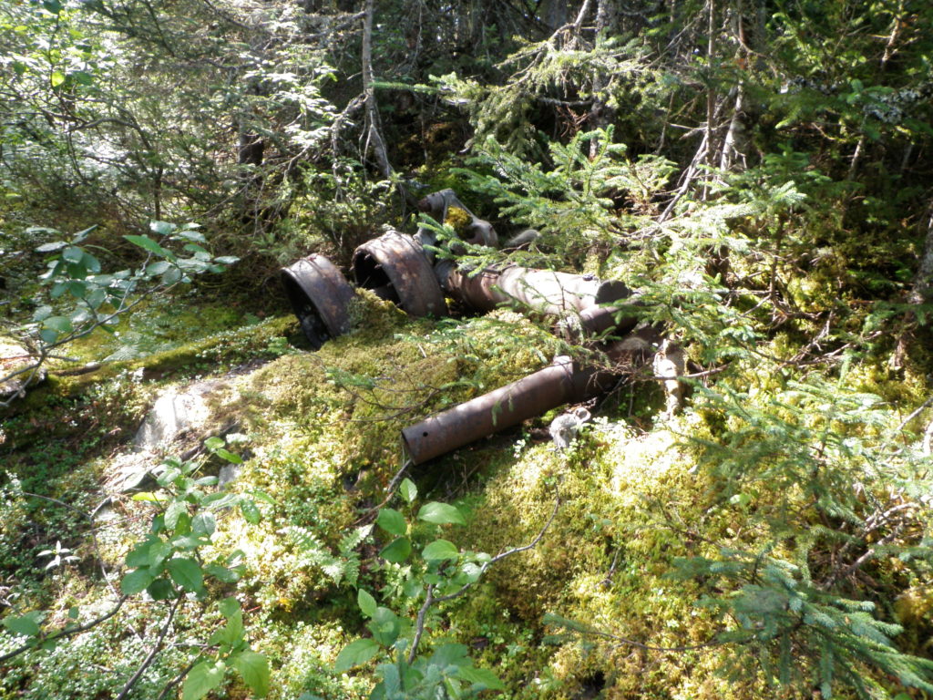
The last post looked at the B-17 that can be found in the Thomas Howe Demonstration Forest in Gander, and discussed what can happen to sites when they are not offered protection but yet are accessible to the public. Prior to the creation of Thomas Howe, the highway was put through the area and the crash site became much more accessible. Due to its accessibility, a lot of the wreckage has been removed. It’s a common theme, and happens whenever a road passes near a site. I’m not saying that everything needs to stay just as it is, but if aircraft material is removed from a site without anything being recorded, the information it can give is lost. This information can give more information about what happened, but if all that is left are a couple of landing gears (figure 1) and bits of steel, the site can really tell us nothing about what happened.

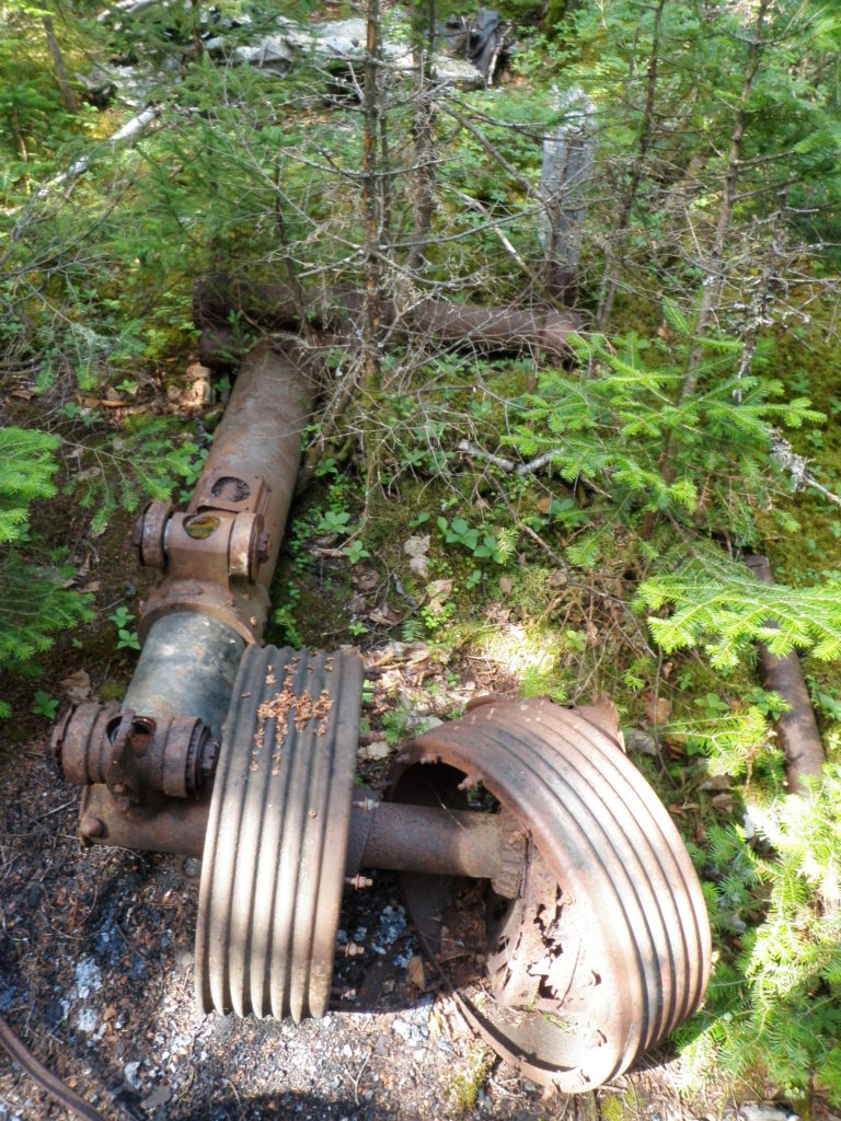
Figure 1: Landing gear with some evidence of fire. Photo by Lisa M. Daly, 2010.

In the Gander area, USAAF B-17 44-6344 can be found between the Thomas Howe Demonstration Forest and the Silent Witness Memorial. It is just off the Trans-Canada Highway, and is relatively accessible. For this reason, there is very little that remains on the site. In fact, there is what looks to be a fire pit where people who were visiting the site stopped and had a lunch, leaving behind their pop bottles (figure 2).

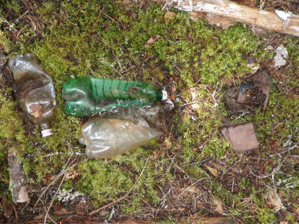
Figure 2: Modern pop bottles on site. Photo by Lisa M. Daly, 2010.

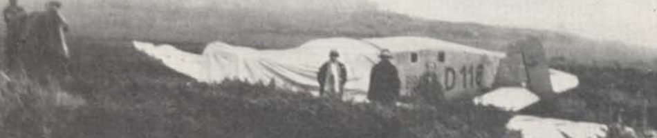
USAAF B-17G 44-6344 crashed 4 August 1944 at 0218GMT. The aircraft made a normal takeoff from runway 23 (235 degrees) en route to the Azores, rose in a steep climb to 200 to 400 feet in a light rain, when the aircraft’s left wing began to drop as if the aircraft were going to make a diving turn. Witnesses described the dip in the wing as resembling a stall (figure 3). The aircraft descended at a 30 to 40 degree angle, and disappeared from view behind the trees. It crashed left wing first and exploded immediately in a 200 to 300 foot high flare (Blackeslee et al. 1944). An eye witness, USAAF navigator Andrew H. Hines, Jr. remembers the crash as follows:

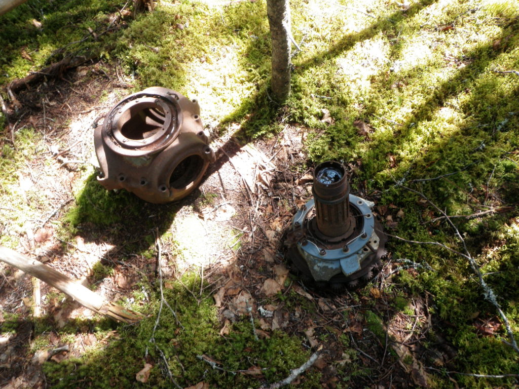
Figure 3: Propeller hub on site. Photo by Lisa M. Daly, 2010.

Air traffic on the North Atlantic crossing was severely impaired. At the time our aircraft was scheduled to cross, planes were beginning to “pile up”, awaiting weather, and it became necessary to move them out. On approximately August 4th we were scheduled to fly the next leg of our trip – Gandar [sic] to Azores.

Our crew was briefed for the flight and we were assigned the position of number 3 for takeoff. As we taxied toward the end of the runway we could see in the east lightning and bad weather from an approaching storm. At the end of the runway we stopped while number 1 took off. He cleared the end of the runway successfully and disappeared into the murk of the approaching bad weather.

Number 2 pulled out on the runway and accelerated for take off. As number 3 we pulled out behind the vacated area and began engine acceleration for our own take off. Number 2 cleared the runway and climbed slightly then heeled over and crashed into the ground. The sky lit up. As number 2 struck and caught fire, our pilot accelerated our engines and we began to roll toward our own take off. We cleared the end of the runway and lifted into the air slightly and flew by the burning wreck of number 2. It was a boiling sea of flames. No one escaped alive. We passed, gained altitude and were immediately in a zone of St. Elmo’s Fire. A ring of sparks marked the tips of our four rotating propellers. Arcs of static electricity began to dance though the aircraft. […] After a few minutes we left the disturbed weather. I had a clear sight of St. John’s which I used as a point of departure for our flight to the Azores (pers. comm. 2 Aug 2013; see table for crew).


Name Serial No. Rank Serial No. Unit Duty Injuries
Oppenheimer, Saul J. 819304 2nd Lt. 819304 15th AF Pilot Fatal
Wampler, Chester C. 767028 2nd Lt. 767028 15th AF Co-pilot Fatal
Hild, Malcolm H. T3200 F/O T3200 15th AF Navigator Fatal
Harrog, David L. 719071 2nd Lt. 719071 15th AF Bombadier Fatal
Faulconer, Warren G. 13143604 Sgt. 13143604 15th AF AEO Fatal
Lawson, Gordon T. Jr. 17072183 Cpl. 17072183 15th AF ROB Fatal
Ruggeri, William 36559279 Cpl. 36559279 15th AF AB Fatal
Shelley, Keith M. 13092412 Cpl. 13092412 15th AF AROG Fatal
Leathers, Maurice E. 37678642 Cpl. 37678642 15th AF AG Fatal
Taylor, Forrest G. 19054972 Cpl. 19054972 15th AF AAG Fatal

Crew list for USAAF B-17 44-6344. Adapted from Blackeslee et al. 1944.

One pilot, Stanley L. Anderson, attempted to contact the control tower to inform them of the crash, but other aircraft interfered with getting through. After trying four times, Anderson went directly to Control Operations and informed them of the crash. The subsequent investigation could not find the cause of the accident, but believed that it was due to an engine stall. The aircraft had had some maintenance done on its flight indicator, but the investigation found that this was not a factor in the crash (Blackeslee et al. 1944).

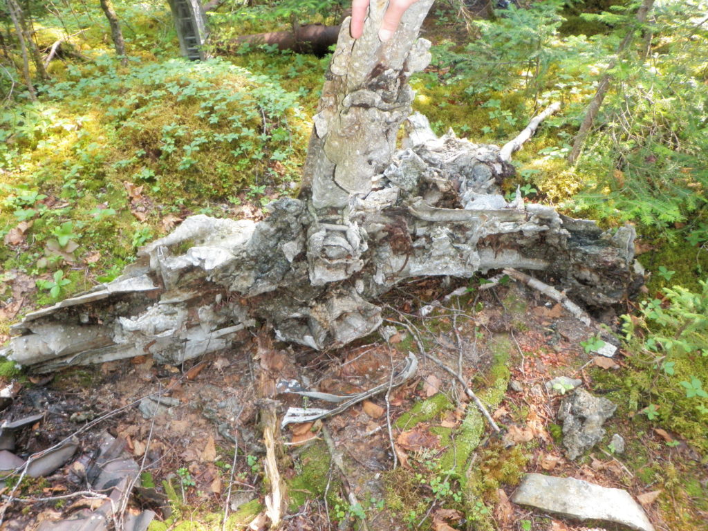
Figure 4: Melted aluminum. Photo by Lisa M. Daly, 2010.

As previously stated, there is very little left to this aircraft, just a few larger pieces like landing gears. All aluminum and copper has been removed from the site, except for a little bit of melted aluminum (figure 4). According to Frank Tibbo, some of the damage was due to a forest fire in that area, and the scars of that can be seen in how the area has fewer trees than the surrounding forest. It is unknown if the melted aluminum is from the heat of the crash or the later forest fire. That said, some of the wreckage could have been removed when highway crews were putting in a culvert close to the site, or some could be covered by the highway (figure 5).

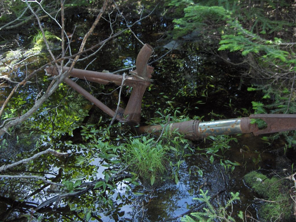
Figure 5: Wreckage in the drainage ditch near the highway. Photo by Shannon K. Green, 2010.

This site is an example of what can happen to sites if they are accessible and not protected, especially when the cost of scrap metal is high. Most sites I have visited show at least some evidence of trying to remove aluminum, and I have been asked by people “how much copper is still there?” which is usually a red flag to not tell that person where a site is located. While most people will respect a site, especially if there is some form of memorial present, it only takes a couple of people to completely destroy a site.

Measuring the artifacts on site. Photo by Shannon K. Green, 2010.

Sources

Blackeslee, H.B., W.H. Lang and J.E. Stewart
1944      War Department U.S. Army Air Force Report of Aircraft Accident. War Department, Gander, Newfoundland. Ms. available from http://www.accident-report.com/.

Hines, A.H.
2013 Personal communication via email, 2 August 2013

Tibbo, F.
2010 Personal communication

Share Button

Some of the sites that I investigated as part of my thesis had very little remaining on site. This was seen with the Ferry Command Hudson FK690, and will be seen with future posts. Whenever a site is accessible, it is at risk to have objects removed, whether for collectors or to sell as scrap metal. In the case of Hudson FK690, the public were encouraged to remove pieces as the highway was supposed to pass over the crash site, but in other cases, it was accessibility which caused the destruction of a site, not permission.

USAAF B-17 42-97493 (DfAp-09) can be found in the Thomas Howe Demonstration Forest in Gander, Newfoundland. This is an educational facility that demonstrates the history of forestry in Newfoundland and forestry practices. It consists of a series of beautiful trails and interpretation panels (map 1). The Demonstration Forest includes a wonderful picnic area which overlooks Gander Lake, and a longer trail which goes from Thomas Howe to the Silent Witness site. I have enjoyed the trails within the Demonstration Forest, but have not yet enjoyed the longer trails or the snowshoe trail.

Map 1: Trail Map for the Thomas Howe Demonstration Forest showing the location of the B-17. From www.GanderCanada.com

Along the P.G. Tipping Trail there sits one of the B-17s engines (figure 1 & 2). This is the largest element which remains of this aircraft, and it is in full view for anyone walking the trail. The wreckage does continue off trail, and down into the trees. To complete this survey, I had to get permission to go off-trail. This survey was done a little more carefully than most because it had to be done with as little impact to the site as possible. In other situations, it was permissible to uncover wreckage, turn pieces over, and to remove branches that were within the line of site of the surveyor’s level (figure 3). This means that some measurements are estimated, and extra care was taken to leave as little evidence of the work as possible (a datum peg was left on site for any future archaeologist who wishes to build on this work). In exchange, the Thomas Howe Demonstration Forest was given a copy of the crash report (available from AAIR), an inventory of what was found on site, and my own report. This they could use to monitor the site and to use in the training of new staff.

Figure 1: The engine visible from the Tipping Trail. Photo by Lisa M. Daly, 2010.

Figure 2: Photo of one of the engines taken at the time of the investigation. Bollis et al. 1944.

Figure 3: Some wreckage was obscured by the forest. Photo by Lisa M. Daly, 2010.

On 29 December 1943 at 2303 GMT, USAAF 42-97493, took off from runway 27 into the wind in “a normal manner” (Bollis et al.1944). The aircraft was departing Gander for Valley, Wales. According to the crash report, the aircraft climbed steeply – so steeply that one witness, F/O Fisher, remarked that the climb was similar to that of a single engine bomber rather than a B-17 – to about 500 to 600 feet then banked to the left to turn to the south. At approximately 15 degrees into the turn, the nose of the aircraft dropped suddenly. Cpl. George W. Stiffler witnessed the crash from the Gander Control Tower, and stated that the engines did not appear to be having trouble, with the exception that three engines were exhausting blue flame and the #1 engine was exhausting yellow flame. The aircraft was still in a turn when it crashed. Witnesses and investigators agree that the left wing touched first, the aircraft caught fire immediately, skidded several hundred feet, and then exploded with flames shooting 500 to 600 feet into the air. All crew and passengers were killed (table 1; Bollis et al. 1944).

Name Rank Serial No. Duty Injuries
Ryan, Bruce E. 1st Lt. O-795488 Pilot Fatal
Wooten, Stephen A. 2nd Lt. O-519302 Pilot Fatal
Gentile, John J. 2nd Lt. O-798698 Navigator Fatal
Thayer, Charles (MMI) Sgt. 37212166 Engineer Fatal
Norton, Frederick A. Cpl. 12092803 Radio Operator Fatal
McCain, Ballard D. 2nd Lt. O-803839 Pilot Fatal
Lineham, Paul J. 2nd Lt. O-811689 Navigator Fatal
Killela, Thomas R. S/Sgt. 32455257 Engineer Fatal
Nightower, Howard W. Sgt. 14140152 Radio Operator Fatal
Boucher, Daniel L. Sgt. 39555248 Gunner Fatal

Table 1: USAAF 42-97493 B-17 crew and passenger list. Adapted from Bollis 1944.

At the time of the crash, RCAF B-24J 593 was making its initial approach to Gander and witnessed the incident. The Liberator circled the crash and gave the control tower the position of the crash before landing (figure 4). The accident investigation team arrived at the scene at 1230 GMT, on 30 December 1943. The path of the aircraft was observed, as well as several parts of the aircraft (figure 5). The investigation concluded that, as observed by witnesses, the aircraft did strike the ground while on a 15 degree bank to the left. The left wing was torn completely off and was about 50 feet to the left of the fuselage. The right stabilizer was found about 100 feet from where the aircraft first impacted the trees, and the fuselage was broken into several pieces (figure 6). The nose and the pilot’s compartment was demolished and burned. The tail broke off, and all four engines and propellers were demolished or severely damaged. The damage to the engines, propellers, and cockpit was severe enough that neither engine could indicate power output, or lack thereof, nor could the instrument readings at the time of the crash be determined. Therefore, the investigator, Major Richard Loomis, could not determine the cause of the crash (Bollis et al. 1944).

Figure 4: View of where the aircraft damaged the trees as it crashed. Bollis et al, 1944.

Figure 5: Pictures of the wreckage taken at the time of the investigation. Bollis et al 1944.

Figure 6: Possible image of the wing or fuselage taken at the time of the investigation. Bollis et al. 1944.

The aircraft was checked prior to takeoff, with all checks being deemed “O.K.” Issues of an oil leak and problems with the carburetor heat gauges were reported, but were signed off on. Minor maintenance was done to the radio equipment, with a new fish put on antenna band A. Mechanical problems were not blamed for the accident. Overall, the cause of the accident was never determined (Bollis 1944).

Map 2: Site distribution with the trail as reference. Created on Surfer 8.

The crash report indicates that the debris was spread over a large are, but, as can be seen by the site map (map 2), there is very little that remains. The majority of what was found was in a relatively clear area, and nothing was found deeper into the trees (figure 7). It should be noted, that most of what was found was not useable for scrap material, and even though only one engine was found, others, especially if they broke apart during the crash, may have been removed either during the investigation or later. Images from the time of the crash show much more material that was once on site. Talking to staff members, they would notice things moving around the Forest. For instance, one staff member found an oxygen tank learning against a pole in an area cleared for the power lines. Yes, oxygen tanks, when punctured, can travel huge distances, but for this one to be found in an area cleared after the crash and to be highly visible would indicate that it had been placed there recently. The staff member decided it would be best to remove the tank and store it at the interpretation centre (figure 8).

Figure 7: Looking at what remains of the aircraft on the site. Photo by Lisa M. Daly, 2010.

Figure 8: Oxygen tank recovered by Thomas Howe Demonstration Forest Staff. Photo by Lisa M. Daly, 2010.

One of the goals of this particular project was to help with the preservation of this site. As seen, the site has been heavily scavenged over the years, and while staff cannot continuously monitor the crash site, they can use the archaeological inventory and map to have an idea of what was on the site in 2010 and if things are being removed or moved around the site. This can help them better manager the site and know if anything further needs to be done to protect the site.

As of now, the crash site is not just a memorial to those who died in the crash. It is also used as a teaching tool. When it comes down to it, it is the Thomas Howe Demonstration Forest, and it demonstrates the life and management of a forest. The crash site is used to teach visitors and school groups about how catastrophic incidents, such as a plane crash, can impact a forest by noting how 70 years later the area is different, but also how it has recovered.

Photo by Lisa M. Daly, 2010.

Sources

Bollis, W.L.J., R. Loomis and W.D. Ward
1944      Accident No.44-12-29-582,” U.S. Army Air Forces Report on Accident.  War Department Report.

Interpretation panel in the Thomas Howe Demonstration Forest giving information about the crash. Photo by Lisa M. Daly, 2010.

Share Button